Rhode Island Roads - US 1

Note the "U.S." in newer shields across RI, like in California.

The southernmost extent of the square shield in RI, here in Westerly.

Sign salad NB entering the state in 1977 (hence the outdated red STOP sign), courtesy Michael Summa. Similar signs with tacked-on arrow panels are still around today, but not with black-background shields.


These are at RI, not US, 1A. The second photo gets it right, but forgets to add the "SCENIC" and make the shield green.

This is one of three or four styles of U-turn signage along the US 1 expressway.


Old, rusted guiderail on old alignments of US 1, probably dating from the construction of the expressway right next to those old alignments.


Two old guide signs along US 1 NB at the beginning of RI 2. The exit is only on the SB side, meaning NB traffic must use a U-turn to get to it (and traffic from RI 2/112 to US 1 NB has the same issue). There used to be more old signs pointing the way to the beach along this exit, but I didn't get those at any good resolution.


SB old signs with another version of the U-turn arrow. This is the same interchange as RI 2/112, but the opposite side, where old 2/112 connect a long block away to RI 1A (original US 1). Thus SB beach traffic gets the same problems as NB RI 2 traffic.


SB, these are both approximately correct ways of signing RI 1A, the coastal route for US 1 (and very often, as in this case near Charlestown, the original Post Road). The second is closer, although R.I. usually doesn't appear in the shield and the font is wrong anyway, while the first would be alright except it needs to decide on a color scheme: shields are either all green (one of two colors, depending on age), or all black.


The word "Old" is greened out on both of these old Post Road signs, NB and SB respectively. Evidently, over the last 20-30 years, Perryville decided it doesn't like the fact that the Post Road is so old.
 RI 108 SB, NJ-style.

The beginning of RI 4 from US 1 NB - after this, US 1 is a two-lane surface street; RI 4 steals the expressway status. RI 4 takes you to I-95.


The semi-ruins of an old stone wall along an old alignment of US 1. Probably built in the 1800's or maybe even 1700's, along with either the original Boston Post Road (actually the Lower Post Road; US 44 in CT is the Middle and US 20 in MA is the Upper) or a very early reconstruction of it. They were used to delineate property lines (which is why in New England, stone walls will often run next to no road at all), and also to prevent people from ducking tolls (which is why "shunpikes" were built).

Not everything fits on this SB LGS. RI 138 has a brief multiplex for now, between the end of its freeway and the surface road to the west. That freeway is slated for completion to I-95 - see the RI 138 page.

Old font, faded numerals, SB just as the ramp leaves.
 NB approaching NJ 12... RI 12, anyone? Hello, RIDOT?
 SB leaving Providence.


In Providence, along US 1 NB (but there are no reassurance shields). Ped-WHAT? Yup, it's by the train station. Incidentally, US 1 here is a two-lane road with room for parking on both sides, but of course you can't stop here. Providence wants to make damn sure you keep on moving, though I'm sure that all breaks down whenever a train's coming in during college move-in/move-out days and major holidays. You'd never realize this little street is US 1 without consulting straight-line diagrams. Signs are getting better, but still are far from competent in leading US 1 traffic through the city.


Sitting in the median at Gregg's (a restaurant), facing SB traffic, is an original Boston-Providence Turnpike milepost. I assume the CH is Court House, a common abbreviation in the early 19th century.

This is the oldest of just three US 1 shields SB between Providence and the MA border, and just one of four total in that area. And in Pawtucket, which falls in that range, US 1 goes through the Mixed-Up Mile (read about it on the I-95 page, linked below). At least recently, Providence got a few US 1 signs on wooden posts, but it's not nearly enough.


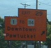
US 1 NB exiting I-95 in that Mixed-Up Mile, with two temporary construction signs that seemed to have become permanent, but I think they're gone now. That shield isn't quite the right blend of colors.

This cement post at the RI-MA border on US 1 is probably from Old Post Road days (yes, yes, note the irony of there being an old post there).
Follow US 1 into MA
Follow US 1 into CT
Onto RI 3
Onto RI 1A
To US 1A instead
Onto RI 4
Onto RI 138
To I-95
Onto RI 113
Onto RI 12
Onto RI 2
Back to Rhode Island Roads
Back to Roads


 RI 108 SB, NJ-style.


 NB approaching NJ 12... RI 12, anyone? Hello, RIDOT?
 SB leaving Providence.


