Québec Roads - A-55, A-10/55
Autoroute 55 and 10/55
A-10 and A-55 duplex

NB/EB courtesy Averill Hecht. These exit numbers, which belong to A-10, originally corresponded to those of A-55 until A-10 was extended to Sherbrooke (thanks to Stéphane Dumas for confirmation).

Even after the renumbering, many exit tabs with arrow diagrams survive. This is the only NB/EB one I got, from the QC 220 overpass.


NB/EB again, courtesy Chris Curley. A-10 now ends at this interchange, and the very poor shield removal jobs tell you what the tacked-on, taped-over shields confirm - what was A-10 until 2006 is now A-610, for the short spur east to QC 112. This doesn't make sense - A-10 should be truncated back to its western junction with A-55, instead of ending ueslessly along a multiplex.


Southbound from Sherbrooke almost to Magog. It almost seems like you could peel off the A-10 exit numbers to reveal 55's numbering, since 10 is no longer a through route. 5 km is a long advance distance for an exit (over 3 miles), but QC 112 is an important junction - it's where the freeway bypass of Sherbrooke tied into the original surface highway. Now, QC 112 acts as frontage roads for a few km before striking out into Magog. On the other side of Magog, A-10 and QC 112 stay very close to each other for some distance more, fueling the theory that the Magog bypass was completed later than the surrounding freeways. Note that Sortie 123 is already signed as being close to Sortie 128 - that's because traffic needs time to merge into QC 112 WB and then get over to the actual exit. The distance from here to the EB offramp just may be 5 km, even if it's closer to 1 km for the WB exit.


Past the characteristic Québec dot, used to keep signs shorter, and leaving the QC 112 alignment. A-55 is given the exit number here, which makes sense because the numbers belong to A-10, but doesn't make sense because this is the first time A-10 has been its own route.
A-55 alone


SB from Richmond to Sherbrooke. Since this is a different country with a different manual on signage standards, I don't know what destination would have fit onto the Sortie 71 BGS. By the last couple of photos, I've approached the beginning of the A-10 multiplex at A-610 (former 10).


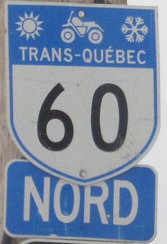
Off of Sortie 60, there's an old cracked shield on Rue du Parc-Industriel, and then QC 538 off to the side. That's one of the province's snowmobile routes, not especially effective in the summer (though perhaps useful as a hiking trail, some of those distances would take all day to walk). The first snowmobile photo is SB, the second NB - signage of course has different priorities, including more attractions, and can ues smaller font, but there appears to be a good standard in place (except when the contractor shoved the arrow on top of the shield). Then again, the CLUB DE MOTONEIGE sign hints that these signs were erected by a local snowmobile club, so standards may vary by region.

A-55 NB at the renumbered Sortie 85, courtesy Averill Hecht. This seems to be a very economical way to tell you the exit number changed, though unlike with the NEW EXIT XX tabs that Pennsylvania uses, the entire sign will have to be replaced once Québec is done telling you the new exit number. This appears to have been a one-time error in exit numbering, based on a 1995 atlas that SPUI procured.


Something for everyone! For the ironist: As if you needed to know that Vermont isn't a town in Québec. For the nudist: Québec swears by graphic realism! (This example is on the Sortie 111 ramp, but there are others - sorry, no close-up, this is a family site.) For the humorist: Imagine the possibilities with a town named Asbestos. Sadly, the other town names give away that there is a lot of English influence here, obviating jokes about fooling the French speakers into living among asbestos ("We may not have driven you away, but we can slowly kill you off").


Southbound photos along the remaining Super-2 freeway from Bécancour (home of the best poutine in the world) south to Sainte-Eulalie. Click on the second photo to turn winter into summer. A lot of this freeway is new as of 2006; before then, traffic had to use QC 155 or QC 161 to get around the gap. Also, as new as part of it is, the entire Super-2 is on track to be dualized in the next few years. As you can see, the overpasses are ready. It's a shame that after all these years, A-55 finally ties seamlessly into A-955, but 955's hopes of carrying the A-55 designation to Richmond have been permanently dashed.


A-55 NB through the same Super-2 stretch in 2014, proving that it was never actually dualized despite all the overpasses being ready.

Photographed by Averill Hecht just before one section of A-55 was dualized, a very American pennant sign but with the European no-passing symbol. Never seen one of these myself, but I would think Canada would rather use the full European standard (white square with colored cars).

In 2km, the 2006 stretch of A-55 comes to the old end of the freeway. QC 155 joined the freeeway from the west and QC 161 ended on the east side of the interchange, which explains the patches top and bottom.
It's all well and good to sign A-30 here, except Ouest won't take you very far, because a few hundred meters to the west is QC 132, where this stub of A-30 currently ends and is likely to end for a good many years before the gap is filled. Which of course makes it all the stranger why QC 132 is signed straight ahead along the NB frontage road, instead of Est being straight and Ouest being signed here instead of A-30.


Southbound across the Fleuve St-Laurent, with the only blurry photo I took obscuring the old diagrammatic exit tab for Sortie 176 (A-30/QC 132). Now that there's a barrier in the middle, the lane use arrows seem redundant, but I suppose there could always be an incident requiring two-way flow on one side. The southbound drive continues with a video.


Now in the NB direction, see a sunroof-exclusive view of how the truss holds the bridge up. The road pulls down on the paired cables, which pull down on the vertical truss member and induce forces in the horizontal (top-bottom) and lateral (left-right) members as well. The lateral members balance the forces across the bridge to prevent twisting of any kind, while the vertical and horizontal members combine to effectively form a very tall and narrow I-beam - the rigidity of the structure is in the height of the truss, not the vertical members.


Continuing north past one more old sign into the half-completed A-40 interchange. A-40 goes through the city of Trois-Rivières, but that probably would have been a three-digit spur had the autoroute been completed to the east at this interchange. I tell much more of that story on the A-40 page linked at bottom, where I also have photos from the freeway stub to the east. Here you see the stub and grading for the NB-EB ramp and the merge from the WB-NB ramp - only the A-40 freeway mainline was fully cleared and graded. Perhaps not coincidentally, A-40 ended here at A-55 for many years before being extended to Québec City.


Southbound at the exit to A-40 to the west, past the stub of the SB-EB would-be loop ramp, and then multiplexed with A-40 EB past an old exit tab that did come out okay (using A-40's exit numbering). To briefly touch on the Boulevard des Forges exit, it's incorrect - this is Boulevard des Chenaux, which does intersect Boul. des Forges nearly 3 km to the east, but that's hardly a reason to sign the exit this way.
Don't forget the video crossing the St. Lawrence River!
Onto A-10 alone
Into Vermont on I-91
Sortie 128 or 143 to QC 112
Sortie 140 to A-410
Sortie 143 to A-610
Sortie 176 to A-30
Sortie 176 to QC 132
Onto A-40
Back to Québec Roads
Back to Roads