Prince Edward Island Roads - Route 12
Route 12


NB and SB at Route 2. The font on the NB sign seems unusually narrow, but that may just be to fit Southwest Lot 16 onto the sign. I'm amazed the residents haven't come up with something better for a name.


NB from Black Ferry Rd. to Route 132. The church is St. Patrick's in Grand River. Of all the brightly painted churches on the island, this yellow one is my favorite.


If you continue straight at Low Point, you head to Green Park past the second photo. Turning left keeps you on Route 12 to see the third sign at the southern end of Route 166.


SB from Route 166 back to Route 132. Hope you like green signs.


Same sign, two different intersections. NB, the sign is at Chapel Rd., which is your second chance to get to Bideford after Route 166. SB, the sign is at the northern end of Route 166, and you're only given this one chance to go to Bideford. Obviously, SB traffic could turn at Chapel Rd. or NB traffic could use the far end of 166, but PEI tries to keep its signs practical.


The jury is out as to whether Canadian Road is just another name for Route 168 or also the name of a settlement up that road. The colorful sign at the bottom of the Route 142 assembly is for the North Cape Coastal Drive, even though the North Cape by no means has a monopoly on PEI lighthouses. These are NB.


Route 12 meets up with Route 2 for a short while in Portage. That's the first photo, where Route 12 SB turns left onto Route 2 EB. Yes, all this time after Routes 2 and 12 crossed, they come back together despite one being N-S and the other being E-W. That's just the nature of directions on this island. The second photo, the flagship of this page, is at Oatway Rd. As far as I can tell, green signs have replaced these, because these are the 2nd through 4th signs of the four that I saw on the entire island. What a shame.


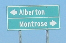
NB from Route 172 (which heads straight) past Ashley Rd. to Route 152 in Alberton.

That was a serious detour for Route 12, so I backtracked out via Route 152 and came back to this photo on Hardy Rd.


NB to Route 161 past Jacques Cartier Provincial Park, where there's decent enough scenery (especially for PEI) but also a restored or replica airplane coming in over the water. It doesn't look like much from here, but it certainly wasn't your standard glider.

SB from the North Cape at Route 182. Anglo Tignish apparently has a rivalry with plain Tignish, probably a one-sided affair that Tignish just brushes aside.
Onto Route 2
Onto Route 132
Onto Route 142
See the North Cape
Back to PEI Roads
Back to Roads