| section | location | date |
| 1 | 47 to 168 | 1928 |
| 561 to 70 | ||
| takeover | 70 to 38 | 1936 |
| ends at Delsea Dr/Fairview-Sewell Rd/Egg Harbor Rd/Blackswood-Barnsboro Rd (47) | |
| Deptford | Hurffville Rd, Clements Bridge Rd |
| Runnemede | Clements Bridge Rd |
| Barrington | Clements Bridge Rd |
| Haddonfield | Chews Landing Rd, Kings Hwy |
| Cherry Hill | Kings Hwy |
| Maple Shade | Kings Hwy |
| becomes Burlington CR 611 | |
| section | location | date |
| (73) 5A/6A/7A | ACE to US 30 | 1970 |
| 4 | US 30 to Cooper Rd | 1931 |
| 3 | Cooper Rd to Maple Ave | 1930 |
| 2 | Maple Ave to 41 | 1930 |
| 1 | 41 to Tacony-Palmyra Bridge | 1931/32 |
| section | location | date |
| takeover | Ferry Ave to ? | 1927 |
| 7 | Camden/Gloucester county line to 555 | 1932 |
| 8 | 555 to US 322 | 1933 |
| 1/2 | US 322 to Gloucester/Atlantic county line | 1930 |
| 5 | Gloucester/Atlantic county line to 559 | 1931 |
| 6 | 559 to 50 | 1931 |
| 6C | 50 to US 40 | 1931 |
| section | location | date |
| (I-76) 1F/2C | US 30 to Atlantic Ave | 1972 |
| (I-676) 1C | Atlantic Ave to Morgan Blvd | 1980 |
| (FAI 109) 1A | Morgan Blvd to I-76 | 1957 |
| 12A/12B/12D | I-76 to US 130 | 1957 |
| 13B/14A/12E/13C | US 130 to I-295 | 1957 |
| 12/13/14 | I-295 multiplex | 1957 |
| 13C/13D/14A/14C | I-295 to Camden/Gloucester county line | 1958 |
| 13D/14C | Camden/Gloucester county line to Gloucester/Camden county line | 1958 |
| 14B/14C/15A | Gloucester/Camden county line to 168 | 1958 |
| 14E/14F/15B/15C | 168 to ACE | 1959 |
| ends at Sicklerville Rd (US 322) | |
| Monroe | Black Horse Pike |
| Washington | Black Horse Pike, North-South Fwy |
| Gloucester | North-South Fwy |
| Deptford | North-South Fwy |
| Runnemede | North-South Fwy |
| Bellmawr | North-South Fwy |
| ends at I-295 (I-295) | |
| section | location | date |
| 8 | Camden line to 41 | 9/1/1919 |
| 9 | 41 to Berlin Ave, Stratford | 9/1/1919 |
| 10 | Berlin Ave, Stratford to 534/561 | 9/1/1919 |
| 1 | 534/561 to Burnt Hill Rd, Waterford | 4/1/1918 |
| 7B | Burnt Hill Rd, Waterford to 536 | 4/1/1918 |
| 7A | 536 to 143 | 4/1/1918 |
| 2 | 143 to Camden/Atlantic county line | 4/1/1918 |
| 12 | Camden/Atlantic county line to 54 | 6/1/1919 |
| takeover | 54 to Egg Harbor Rd, Hammonton | 6/1/1919 |
| takeover? | Egg Harbor Rd, Hammonton to Elwood | 6/1/1919 |
| takeover | Elwood to Egg Harbor City | 6/1/1919 |
| 3 | through Egg Harbor City | 6/1/1919 |
| 13 | Egg Harbor City to 6th Ave, Galloway | 1924 |
| 14 | 6th Ave, Galloway to 157 | 1924 |
| section | location | date |
| (17-S) takeover | 47 to High Hill Rd, Logan | 1926 |
| (17-S) takeover? | High Hill Rd, Logan to Gloucester/Salem county line | 1927 |
| (17-S) takeover? | Gloucester/Salem county line to Penns Grove | 1926 |
| section | location | date |
| takeover | Penns Grove bypass | 10/24/1939 |
| takeover | Penns Grove to Deepwater | 7/2/1935 |
| takeover? | Deepwater to Pennsville | by 1941 |
| takeover? | Pennsville to Salem | after 1941 |
| section | location | date | notes |
| 17A | Delaware Memorial Bridge approach to Hollywood Ave | 1953 | |
| not built here until later | |||
| 8 | Bridgeport bypass | 1941 | |
| 8A/16B | Bridgeport to I-295 | 1954 | |
| 9C/11B/14B/15C | I-295 to Woodbury Creek | 1954 | |
| 9A/9B | Woodbury Creek to US 130 | 1948 | upgraded partially on the spot |
| ends at Barkers Ave | |
| Logan | Crown Point Rd |
| Greenwich | W Broad St, E Broad St |
| Paulsboro | W Broad St, E Broad St |
| West Deptford | Crown Point Rd |
| ends at U-turn (Exit 22 onramp to I-295/US 130 southbound) | |
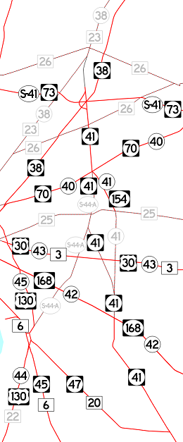
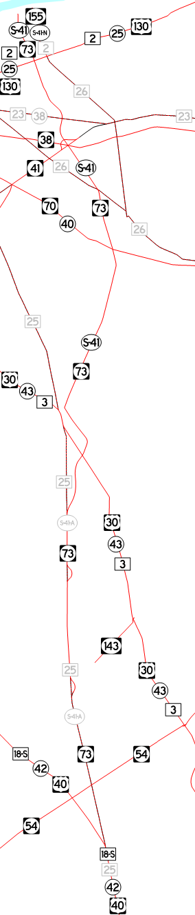
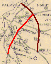
 A tunnel was planned across the Delaware River from roughly Paulsboro to Essington, PA, and the approach was planned as 44T. As shown to the left from the 1942 NJSHD Annual Report map, 44T would have run south from the bridge, looping back around Woodbury and Deptford, ending at 42 (now 168) just south of its junction with 41. 41 is shown as continuing from that point, and the map suggests a short concurrency with 42 instead of turning on 44T. It is also possible that these routings would have been adjusted had 41 been constructed to Haddonfield as shown. 44T became 78 in the GR until the tunnel concept died, at least to the junction with 47 since that number was also assigned to S44T.
| section | location | date |
| (6) takeover | ? to Walnut St, Woodbury | 5/1/1920 |
| (6) 14 | Walnut St, Woodbury to Reid St, Woodbury | 5/1/1920 |
| (6) takeover | Reid St, Woodbury to Mantua | 5/1/1920 |
| (6) 1 | Mantua to Mullica Hill | 5/15/1919 |
| (6) takeover | Mullica Hill to Gloucester/Salem county line | 5/1/1920 |
| (6) 7 | Gloucester/Salem county line to Compromise Rd, Mannington | 5/1/1920 |
| (6) 9 | Compromise Rd, Mannington to Salem | 5/1/1920 |
| section | location | date |
| (6) 6A | Brooklawn to Market St | 1929 |
| (6) 5B/5A | Market St to 168 | 1930 |
| 4B/4C | 168 to US 30 | |
| 4 | US 30 to 38 | 1927 |
| ends at Broadway (49) | |
| Salem | Market St |
| Mannington | Salem-Woodstown Rd |
| Pilesgrove | Salem-Woodstown Rd, Harding Hwy |
| Woodstown | West Ave, N Main St |
| Pilesgrove | Woodstown-Mullica Hill Rd |
| South Harrison | Woodstown-Mullica Hill Rd |
| Harrison | Woodstown-Mullica Hill Rd, S Main St, N Main St, Bridgeton Pike |
| Mantua | Bridgeton Pike |
| West Deptford | Broadway |
| Woodbury | Mantua Pike, S Broad St, N Broad St |
| West Deptford | Howell Ave |
| Westville | Gateway Blvd |
| ends at Crown Point Rd (US 130) | |
| ends at I-80 (I-80) | |
| Knowlton | Route 46 |
| White | Route 46 |
| Liberty | Route 46 |
| Independence | Route 46 |
| Hackettstown | Main St, Mill St |
| Washington | Route 46 |
| Mount Olive | Route 46 |
| Netcong | Lackawanna Pl, Ledgewood Ave |
| Roxbury | Route 46 |
| Mine Hill | Route 46 |
| Dover | W Blackwell St, W McFarlan St, E McFarlan St |
| Rockaway Twp | Route 46 |
| Rockaway Borough | Route 46 |
| Denville | Route 46 |
| Mountain Lakes | Route 46 |
| Parsippany-Troy Hills | Route 46 |
| Montville | Route 46 |
| Fairfield | Route 46 |
| Wayne | Route 46 |
| Totowa | Route 46 |
| Little Falls | Route 46 |
| Woodland Park (was West Paterson) | Route 46 |
| Little Falls | Route 46 |
| Clifton | Route 46, Piaget Ave, Route 46, McLean Blvd, Route 46 |
| Elmwood Park | Route 46 |
| Garfield | Route 46 |
| Saddle Brook | Route 46 |
| Lodi | Route 46 |
| Hasbrouck Heights | Route 46 |
| Teterboro | Sylvan Ave |
| South Hackensack | Route 46 |
| Little Ferry | Route 46 |
| Ridgefield Park | Winant Ave, Route 46 |
| Ridgefield | Route 46 |
| Palisades Park | Route 46, Bergen Blvd |
| Fort Lee | Bergen Blvd, Route 46, George Washington Bridge |
| ends at New York border (US 1/US 9/I-95) | |
| ends at Atlantic Ave | |
| Wildwood | E Rio Grande Ave, W Rio Grande Ave |
| Lower Twp | Wildwood Blvd |
| Middle Twp | Wildwood Blvd, Delsea Dr |
| Dennis | Delsea Dr |
| Maurice River | Delsea Dr |
| Millville | Port Elizabeth Rd, S 2nd St, N 2nd St |
| Vineland | Delsea Dr |
| Franklin | Delsea Dr, Dutch Mill Rd, Delsea Dr |
| Clayton | Delsea Dr |
| Glassboro | Delsea Dr |
| Washington | Delsea Dr |
| Deptford | Delsea Dr |
| Westville | Delsea Dr, Broadway |
| Brooklawn | Broadway |
| ends at Crescent Blvd (US 130) | |
| ends at Virginia Ave (US 130 | |
| Penns Grove | E Main St |
| Carneys Point | Harding Hwy |
| ends at Wiley Rd (US 40) | |
| ends at I-295 (I-295/US 40) and becomes Shell Rd (US 130) | |
| Pennsville | N Broadway, S Broadway, Pennsville-Salem Rd |
| Salem | Griffith St, N Front St, W Broadway, E Broadway |
| Quinton | Salem-Quinton Rd, Main St, Quinton-Marlboro Rd |
| Stow Creek | Salem Pike |
| Shiloh | Main St |
| Hopewell | Shiloh Pike |
| Bridgeton | W Broad St, E Broad St, E Commerce St |
| Fairfield | Bridgeton-Millville Pike |
| Millville | Millville-Bridgeton Pike, W Main St, E Main St, Cumberland Rd |
| Maurice River | Route 49 |
| Estell Manor | Route 49 |
| Upper Twp | Route 49 |
| ends at Route 50 (50) | |
| ends at Shore Rd (US 9) | |
| Upper Twp | Route 50 |
| Corbin | Route 50 |
| Estell Manor | Route 50 |
| Weymouth | Route 50 |
| Hamilton | Route 50, Cape May Ave, Route 50 |
| Galloway | S Philadelphia Ave, N Philadelphia Ave |
| ends at White Horse Pike (US 30) | |
| ends at Palen Ave | |
| Ocean City | Route 52 |
| Somers Point | MacArthur Blvd |
| ends at New Rd (US 9) | |
| ends at Littleton Rd (US 202) | |
| Morris Plains | Old Tabor Rd |
| Parsippany-Troy Hills | Tabor Rd |
| Denville | E Main St |
| ends at Bloomfield Ave | |
| ends at Harding Hwy (US 40) | |
| Buena Vista | Blue Anchor Rd, Buena-Hammonton Rd |
| Folsom | 12th St |
| Hammonton | Bellevue Ave |
| ends at White Horse Pike/Route 206 (US 30/US 206) | |