| section | location | date | what it was previously |
| (10) 2 | Edgewater Ave (Bergen Turnpike) to Central Blvd | 3/9/1920 | Broad Ave south of the split, new east of the split |
| (10) 1 | Central Blvd to ferry docks | 7/11/1918 | Central Blvd for the block west of Anderson Ave, Palisade Ave along it, new elsewhere |
![]() |
ROUTE No. 5. PATERSON TO EDGEWATER, via Maywood, Hackensack, Little Ferry, Ridgefield, Fort Lee to Ferry Plaza at Edgewater. L. 1927, c. 319. ROUTES NO. 5 AND S-5. Ridgefield to Edgewater. Beginning at Ridgefield and terminating at the Ferry plaza in Edgewater with a spur connecting Route No. 5 with Route No. 1 in Ridgefield and Fairview. L. 1929, c. 126, p. 215, s. 5. 5: From junction of Route U. S. 1 (former Route 1) Ridgefield, via former Route 5 to Fort Lee Ferry. 1953 renumbering |
| Left: NJ 5 in 1927. |
| ends at Broad Ave (US 1/US 9) | |
| Ridgefield Park | Route 5 |
| Palisades Park | Route 5 |
| Fort Lee | Columbia Ave, Route 5, Glen Rd, Central Blvd, Palisade Ave, Route 5 |
| Edgewater | Route 5 |
| ends at River Rd (CR 505) | |
| section | location | date | what it was previously | |
| (5) 11 | Delaware River to Manunka Chunk Rd | 1/15/1920? 10/22/1919? | ||
| (5) 17 | Manunka Chunk Rd to 31 | 1/15/1920 | ||
| (5) 18 | 31 to Hope Rd | 1/15/1920 | ||
| (5) 8 | Hope Rd to Hackettstown | 1/15/1920 | ||
| (5) 9 | in Hackettstown | 1/15/1920 | ||
| (5) 2 | Hackettstown to Landing Rd | 1/15/1920 | ||
| Most information east of Landing Rd is not in the SLDs, so I only have some sections: | ||||
| (12) 8 | including Pine Brook | 1/15/1920 | ||
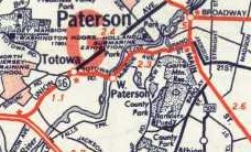
| 62 to Piaget Ave? | ||||
| Piaget Ave? to 21 | ||||
| 20 to 17 | 12/1/1937 | |||
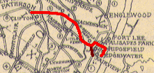
| Bergen Tpk, Little Ferry to Broad Ave, Palisades Park | new | |||
| 1/2 | Broad Ave to Palisades Blvd, Palisades Park | 1931 | new | |
| 3 | Palisades Blvd, Palisades Park to Fort Lee Rd, Fort Lee | 1931 | new | |
| 6 | Fort Lee Rd to George Washington Bridge Approach, Fort Lee | 1933 | new | |
| George Washington Bridge (also 4) | 10/25/1931 | new | ||
| milepost | structure # | crossing | date |
| 32.25 | 1408153 | Landing Rd | 1934 |
| 37.91-37.97 | 1409155 | Blackwell St/Rockaway River/RR | 1929 |
| 38.12-38.17 | 1409156 | RR/15 | 1929 |
| 43.03 | 1410150 | 53 | 1941 |
| 43.40 | 1410151 | Den Brook | 1941 |
| 50.37 | 1410157 | Rockaway River | 1940 |
| 51.43 | 1410158 | Passaic River branch | 1940 |
| 51.54 | 1430150 | 159 | 1940 |
| 51.85 | 1410159 | Passaic River | 1940 |
| 53.10 | 0722150 | Little Falls Rd | 1952 |
| 53.40 | 0722151 | Horseneck Rd | 1952 |
| 53.92 | 0722152 | Hollywood Ave | 1952 |
| 54.48 | 0722155 | Fairfield Ave ramp | 1951 |
| 54.99 | 0722156 | Two Bridges Rd | 1950 |
| 55.45 EB | 0722157 | Passaic River | 1927 |
| 55.45 WB | 0722152 | Passaic River | 1951 |
| 55.61 | 1604411 | West Belt | 1967 |
| 55.98 | 1604158 | 23 south | 1967 |
| 56.17 | 1606174 | RR | 1967 |
| 56.34 WB | 1606175 | 23 south ramp | 1967 |
| 56.37 EB | 1606176 | 23 north | 1967 |
| 56.37 WB | 1606177 | 23 north | 1967 |
| 57.02 | 1606156 | Riverview Dr | 1948 |
| 57.58 | 1606157 | Union Blvd/62 | 1948 |
| 57.90 | 1606158 | Riverview Dr/Passaic River | 1939 |
| 58.04 | 1606159 | McBride Ave | 1939 |
| 58.29 | 1606160 | Peckmans Brook | 1939 |
| 58.73 | 1606163 | Browertown Rd | 1939 |
| 59.06 | 1606165 | Lower Notch Rd | 1939 |
| 59.34 | 1606167 | Rifle Camp Rd | 1939 |
| 60.06 | 1606172 | Valley Rd | 1939 |
| 60.24 | 1607151 | 3 | 1939 |
| 60.91 | 1607152 | Van Houten Ave | 1939 |
| 61.09 | 1607153 | Grove St | 1939 |
| 61.30 | 1607154 | Broad St/19 | 1939 |
| 61.60 | 1607156 | RR | 1939 |
| 61.69 | 1607157 | RR | 1939 |
| 61.75 | 1607158 | Paulison Ave | 1939 |
| 62.36 | 1607160 | Piaget Ave | 1940 |
| 62.53 | 1607161 | Main Ave | 1939 |
| 62.70 | 1607162 | RR | 1939 |
| 63.00 | 1607163 | Lakeview Ave | 1939 |
| 63.27 | 1607164 | Randolph Ave | 1939 |
| 63.85 EB | 1607166 | 20 | 1936 |
| 63.85 WB | 1607167 | 20 | 1936 |
| 63.95 | 1607168 | Passaic River | 1937 |
| 64.07 | 0220150 | 507 | 1939 |
| 65.26 | 0220153 | Midland Ave | 1936 |
| 65.40 | 0220154 | RR | 1936 |
| 66.03 | 0220155 | Outwater Ln | 1936 |
| 66.51 | 0220157 | Saddle River | 1936 |
| 66.56 | 0220158 | Main St | 1936 |
| 67.62 | 0220161 | Valley Blvd | 1936 |
| 67.91 | 0221150 | Terrace Ave | 1936 |
| 68.01 | 0221151 | 17 south | 1936 |
| 68.11 | 0221152 | 17 north | 1936 |
| 68.21-68.27 | 0221153 | RR/Green St | 1934 |
| 70.20-70.42 | 0221155 | Hackensack River/RR/West Shore Ave | 1934 |
| 70.68 | 0221156 | Teaneck Rd | 1934 |
| 71.31 | 0222150 | Overpeck Creek | 1928 |
| 71.53 | 0222151 | RR | 1930 |
| 71.65 | 0222152 | 93/501 | 1930 |
| 71.84 | 0222153 | Broad Ave | 1929 |
| 71.98 | 0222154 | Roff Ave | 1931 |
| ends at US 1-9 Truck | |
| Jersey City | Newark Tpk |
| Kearny | Newark Tpk, Belleville Tpk |
| [Kearny](N. Arlington) | Belleville Tpk |
| Belleville | Rutgers St. |
| ends at Route 21 (21) | |
| ends at Newark/Belleville Line (Second River) | |
| Belleville | Washington Ave |
| Nutley | Washington Ave |
| Clifton | Washington Ave, Kingsland Rd |
| Nutley | Kingsland St, Cathedral Ave |
| ends at Essex/Passaic county line | |
| enters Delaware (US 9) | |
| Lower Twp | ferry, Lincoln Blvd, Sandman Blvd, Route 9 |
| Middle Twp | S Shore Rd, S Main St, N Main St, Route 9 |
| Dennis | Route 9, Shore Rd |
| Upper Twp | Route 9, Shore Rd, Route 9, Somers Point Br |
| Egg Harbor | Somers Point Br |
| Somers Point | Somers Point Br, New Rd |
| Linwood | Route 9 |
| Northfield | New Rd |
| Pleasantville | Route 9, N New Rd |
| Absecon | S New Rd, N New Rd, E Wyoming Ave, N Shore Rd |
| Galloway | S New York Rd, N New York Rd |
| Port Republic | New York Rd, Route 9, Garden State Pkwy |
| Bass River | Garden State Pkwy, Route 9 |
| Little Egg Harbor | Route 9 |
| Tuckerton | W Main St, E Main St |
| Little Egg Harbor | Route 9 |
| Eagleswood | Main St |
| Stafford | S Main St, N Main St |
| Barnegat | S Main St, N Main St |
| Ocean | Route 9 |
| Lacey | S Main St, N Main St |
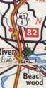
| Berkeley | Route 9, Atlantic City Blvd |
| Beachwood | Atlantic City Blvd, Parkway Access |
| South Toms River | Parkway Access, Garden State Pkwy |
| Berkeley | Garden State Pkwy |
| Dover | Garden State Pkwy, Lakewood Rd |
| Lakewood | River Ave, Madison Ave |
| Howell | Route 9 |
| Freehold Twp | Route 9 |
| Freehold Borough | Route 9 |
| Freehold Twp | Route 9 |
| Manalapan | Route 9 |
| Marlboro | Route 9 |
| Old Bridge | Route 9 |
| Sayreville | Route 9 |
| South Amboy | Upper Main St, Route 9 |
| Sayreville | Route 9 |
| Woodbridge | Route 9, Route 1 |
| Rahway | Route 1 |
| Linden | Edgar St, Carlton St |
| Elizabeth | Carlton St, Route 1, Spring St |
| Newark | McCarter Hwy, Pulaski Skyway |
| Kearny | Pulaski Skyway |
| Jersey City | Pulaski Skyway, Tonnelle Ave |
| North Bergen | Tonnelle Ave |
| Fairview | Broad Ave |
| Ridgefield | Broad Ave |
| Palisades Park | Broad Ave, Route 46, Bergen Blvd |
| Fort Lee | Bergen Blvd, Route 46, George Washington Bridge |
| enters New York (US 1/US 9/I-95) | |
| ends at I-95/Route 46/Route 4 (I-95/US 1/US 9/US 46/4) | |
| Fort Lee | Fletcher Ave, US 9W, Lemoine Ave |
| Englewood Cliffs | Sylvan Ave |
| Tenafly | Palisades Blvd |
| Alpine | Palisades Blvd |
| enters New York | |
| ends at Route 46 (US 46) | |
| Roxbury | Route 10 |
| Randolph | Route 10 |
| Denville | Route 10 |
| Parsippany-Troy Hills | Route 10 |
| Hanover | Route 10 |
| East Hanover | Route 10 |
| Livingston | W Mount Pleasant Ave, E Mount Pleasant Ave |
| West Orange | Mount Pleasant Ave |
| ends at Prospect Ave (CR 577/677) | |