New Jersey Roads - NJ State Highways - 171-208

NJ State Highways: 171-208

171   172   173   174   175   177   178   179   180   181   182   183   184   185   187   I-195   US 202   US 206   Bypass US 206   208


171

171 is a short route heading south from New Brunswick.
25M was designated before 1934 as the number for pre-1927 1 north of the split with post-1927 25, ending at the New Brunswick line where state maintenance ended (and still ends). In the 1953 renumbering, 25M became part of US 130, along with local streets to 27 in downtown New Brunswick. NJDOT truncated US 130 to US 1 in 1958 (or 1963?), and the road north of US 1, including the locally maintained section (inside New Brunswick), became 171. The routing of 171 inside New Brunswick changed at some point; instead of continuing on Commercial Ave to George St (former 18), and presumably turning there on old 18 to get to 27, 171 jogged left on Suydam St to what was once 26. In fact, an old 26 NORTH shield stands on what became 171 north. Around 2018-2019, the city-maintained portion of 171 was dropped and it now ends at the city line. History of the road is in the 25M entry.

Photos
End photos

ends at Route 1 (US 1/US 130)
North BrunswickGeorges Rd
ends at New Brunswick border
New BrunswickGeorges Rd, Commercial Ave, Suydam St, Livingston Ave, George St
ended at Albany St (27)


172

172 is old
18 in New Brunswick. The original route of S28, which became 18 in the 1953 renumbering, entered New Brunswick from the south on George St, with state maintenance ending at Commercial Ave. Construction of a bypass along the river began in 1955, with Burnet St between George St and 27 being taken over and rebuilt by the state. At that time, the state-maintained part of the former alignment (to Commercial Ave) became 172. History of the road is in the S28 entry.

Photos
End photos

ends at Commercial Ave (171)
New BrunswickGeorge St, Route 172
ends at Burnet St (18)


173

173 is old
US 22 from the Phillipsburg area to Clinton; it was designated in 1969 when US 22 was moved onto I-78. History of the road is in the 28 listing.

Photos
End photos

ends at I-78 (I-78/US 22)
GreenwichRoute 173
BloomsburyRoute 173
BethlehemRoute 173
UnionRoute 173, [Rupells Rd, Marginal Rd](Route 173), I-78, [I-78](W Main St)
[Franklin](Clinton Town)[I-78, ramp, Pittstown Rd](W Main St)
Clinton Town[Pittstown Rd](W Main St), W Main St, Old Route 22
Clinton TwpOld Route 22
ends at Route 31 (31)


174

174 was the original number for the
US 1 freeway north of Bus. US 1 near Trenton. The road was built in 1955 south of Whitehead Rd, and it was completed in 1973 to US 1. It remained 174 until 1/1/1988, when old US 1 from the Brunswick Circle exit to the end of the freeway became Bus. US 1, and 174 became part of US 1.

End photos

175

175 is old
29 near I-295 in the Trenton area, and now serves as a frontage road, as well as access for some movements of the 29/I-295 interchange. It was renumbered in 1963. The part of 175 in Trenton never became state-maintained. History of the road is in the 29 entry.

Photos
End photos

ends at John Fitch Pkwy (29)
TrentonSanhican Dr
EwingRiver Rd, W Upper Ferry Rd, Upper River Rd
ends at River Rd (29)


177

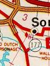
177 was Bridge St in southern Somerville, old
US 206 (or maybe only old pre-GR 31). From information submitted by Myles Putman, Bridge St was likely only taken over due to its realignment at the new US 206 bypass. NJDOT only maintained up until Bridge St rejoined its original alignment, a distance of 0.24 miles. Even though US 206 was realigned as early as 1930 (with the complete bypass open in 1936), only in 1961 did 177 appear in state logs, and it wasn't on the official map until 1970 (and off by 1974).

178

178 was a proposed freeway along the
53 corridor, from the unbuilt 24 freeway north of Morristown to I-80.

ROUTE NO. 178. Added by L.1967, c. 142, s. 1, repealed 1997, c.143, s.3.

History (Steve Anderson).

179

179 is old
US 202 from Lambertville to Ringoes. The mostly-freeway bypass of US 202 around Ringoes opened in 1965, with the freeway extension into Pennsylvania opening on 10/16/1974. At that point, the old route became 179. History of the road is at 29 (the old number north of Lambertville) and US 202 entries. Also, 179 west of 29 was S29 pre-GR after a state takeover of Bridge St.

ROUTE NO. . Beginning at Route 29 in the city of Lambertville and running in a westerly direction to the easterly end of the Delaware river bridge in the city of Lambertville, more particularly known as Bridge street and a portion of U.S. Route 202 in the city of Lambertville. L.1948, c. 407, p. 1613, s. 1.

Photos
End photos

enters Pennsylvania (PA 179)
LambertvilleBridge St, Old York Rd
West AmwellRoute 179
East AmwellOld York Rd
ends at Route 202 (US 202/31)


180

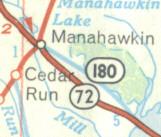
180 was old
72 east of Manahawkin (bypassed 1968); it was turned over to the county (as CR 50) on 4/16/1980 in exchange for 35 south of the Seaside Heights bypass. History of the road is in the S40 entry. The scan at right, from a 1969 map, is provided by Scott Colbert. It appears that NJDOT originally proposed CR 680, but Ocean County uses some two-digit county route numbers.

Photos along the former route
End photos

181

181 is old
15 through Sparta, bypassed 1974. History of the road is in the 6A entry.

Photos
End photos

ends at Espanong Rd/Route 15 (15)
JeffersonWoodport Rd
SpartaWoodport Rd, Mohawk Ave, Sparta Ave, Lafayette Rd
ends at Route 15 (15)


182

182 is a short route connecting
US 46 to 57 and old 24. In the 1927 numbering, 24 went from Phillipsburg to Newark via Morristown. The alignment near Hackettstown used the old Washington Turnpike via Pleasant Grove. S24 split from 24 at Penwell and went to Hackettstown. When the routes were renumbered in 1953, NJDOT abandoned the idea of ever building 24 via Pleasant Grove, and rerouted 24 via S24 to the south edge of Hackettstown, and then south to Schooleys Mountain on the originally planned route. The bit of S24 north of what was now 24 became 57.
On 10/9/1969, the routes were renumbered again. 24 was truncated to only go east of Hackettstown on county roads, and 57 was reassigned to state-maintained 24 west of Hackettstown. The road that had been 57 became 182, since 57 was planned to continue east as a bypass of Hackettstown. That bypass has died, but the 182 number remains. The entire route is multiplexed with CR 517.

Photos
End photos

ends at Route 57 (57/CR 517)
HackettstownMountain Ave
ends at Mill St/Main St (US 46)


183

183 is old
US 206 through Netcong, bypassed 1973. History of the road is in the 31 entry.

Photos
End photos

ends at I-80 (I-80/US 206)
RoxburyLackawanna Pl
NetcongLackawanna Pl, Ledgewood Ave
StanhopeBrooklyn Rd, Route 183
ends at Netcong Bypass/Route 206 (US 206)


184

184 is old
440 in Woodbridge and Perth Amboy, bypassed 1974; most of the road is multiplexed with CR 501, except what is now frontage roads to the 440 freeway (just west of 35). History of the road is in the S4 (pre-GR number) entry.

Photos
End photos

ends at Garden State Pkwy (444)
WoodbridgeKing Georges Rd, W Pond Rd, Pfeiffer Blvd
Perth AmboyPfeiffer Blvd, [Harding Ave](Waltrous Ave)
ends at Convery Blvd (35)


185

185 is a short spur from
440 in Jersey City, opened 2/25/1988 (when 440 in the area was still 169). Only about 1/3 of the planned route has been built, and none of the proposed alternatives have yet to be accepted. The numbering for 185 is similar to 85, which was a freeway proposed in roughly the same corridor, but this is most likely a coincidence.

ROUTE NO. ----. A northerly spur, wholly within Jersey City, Hudson county, beginning in the vicinity of Harbor drive and proceeding in a northerly direction to a connection with Bayview avenue. L.1976, c. 52, s. 1, eff. July 22, 1976.

Photos
End photos

ends at Route 440 (440)
Jersey CityCaven Point Blvd
ends at Linden Ave


187

At some point,
87 was rerouted onto Huron Ave in Atlantic City, and the old route became 187. A 1960 map shows both routes as 87. History of the road is in the S4A (pre-GR number for 87) entry.

Photos
End photos

ends at Absecon Blvd
Atlantic CityBrigantine Blvd
ends at Huron Ave/Maryland Ave (87)


I-195

I-195 runs east from the Trenton area. It was not part of the original Interstate plan. 37 and 38 were intended to be freeways across central New Jersey, with 37 continuing northwest from its present terminus toward Trenton (where I-195 now begins), and 38 continuing northeast from the end of its divided highway (and its former terminus) toward Belmar (where I-195 now ends). Since neither of those routes had funding, but there was a need for a freeway corridor linking the Camden-Trenton area to the shore, Interstate funding was obtained and the compromise route of I-195 was built.

ROUTE NO. . Beginning in the vicinity of a major interchange of State Highway Routes Nos. 29 and 206, in the township of Hamilton, county of Mercer, and thence in a generally easterly direction to an intersection east of Route 130 with the State highway route described in chapter 111, laws of 1953, approved April 22, 1953. L.1965, c. 210, s. 1.

Photos
End photos
History (Steve Anderson)

ends at I-295/Route 29 (I-295/29)
HamiltonI-195
WashingtonI-195
Upper FreeholdI-195
MillstoneI-195
JacksonI-195
HowellI-195
WallI-195
ends at Route 34/Route 138 (34/138)


US 202

US 202 runs southwest-northeast through the northwest part of the state. It was formed in the mid-1930s as a renumbering and extension of
US 122 (connecting with US 202 from Maine southward once New York agreed to sign it). Before the GR, US 202 used pieces of 29, 30 (the current multiplex with 31), and 31 (the current multiplex with US 206), all of 32, and a piece of 23, as well as county roads from there north. The history of US 202 prior to 1953 is contained in all of the links in this paragraph.
Lambertville and Ringoes were bypassed by a freeway on 10/16/1974; the old route became 179. Around that same time, NJDOT boring logs show a potential relocation of US 202 from I-287 all the way into downtown Lincoln Park that suggest it would have been taken over by the state, following the path of the Morris Canal. This was likely killed for environmental reasons, but even decades after its designation, US 202 was still under consideration for upgrade from county maintenance.

ROUTE NO. . Beginning at Route 29 in the city of Lambertville and running in a westerly direction to the easterly end of the Delaware river bridge in the city of Lambertville, more particularly known as Bridge street and a portion of U.S. Route 202 in the city of Lambertville. L.1948, c. 407, p. 1613, s. 1.
U. S. 202: From Delaware River in Lambertville, via former Routes S-29 and 29 to a junction of Route 69 (former Route 30) in Ringoes, coincident with Route 69 to a junction with Route 12 and Route 69 in Flemington, via former Route 29 to a junction with Route 29 and Route U. S. 206 (former Route 31) in Raritan, then coincident with Route U. S. 206 (former Route 31) to a junction north of Somerville with Route U. S. 22 (former Route 29) and Route 28-29 Connecting Link, coincident with Route U. S. 206 (former Route 31), to a junction with Route U. S. 206 (former Route 31) at Bedminster, via former Route 32 at Morris Plains. Route U. S. 202 continues via local roads through Boonton, Mountain View, Pompton Lakes and Mahwah, to the New York State line near Suffern. 1953 renumbering.
ROUTE NO. ----. Beginning in the vicinity of a new bridge to be constructed across the Delaware river, north of Lambertville, New Jersey, and running thence in a general northeasterly direction to a point in existing Route 202 (1953), north and east of Lambertville, New Jersey. Added by L.1967, c. 143, s. 1, eff. July 7, 1967.

Photos
End photos
History (Steve Anderson)

enters Pennsylvania
DelawareRoute 202
LambertvilleRoute 202
West AmwellRoute 202
East AmwellRoute 202
West AmwellRoute 202
East AmwellRoute 202
RaritanRoute 202
FlemingtonRoute 202
RaritanRoute 202
ReadingtonRoute 202
BranchburgRoute 202
BridgewaterRoute 202
RaritanRoute 202
BridgewaterRoute 202
SomervilleRoute 202
BridgewaterRoute 202
BedminsterRoute 202, Main St
Far HillsRoute 202
BernardsvilleMine Brook Rd, Morristown Rd
BernardsMorristown Rd
HardingMount Kemble Ave
Morris TwpMount Kemble Ave
MorristownMount Kemble Ave, [Market St, South St, Mendham Ave, E Park Pl](Bank St, N Park Pl), Speedwell Ave
Morris TwpSpeedwell Ave
Morris PlainsSpeedwell Ave, Littleton Rd
Parsippany-Troy HillsLittleton Rd, Parsippany Blvd, Intervale Rd, Main St
BoontonMain St, Myrtle Ave
MontvilleMain Rd, Route 202, Indian Hill Rd, Main Rd
Lincoln ParkE Main St, Boonton Tpk
WayneBoonton Tpk, Mountain View Blvd, [Mt View Blvd, Boonton Rd, ramp](Sherman St, ramp), Route 23, Oak Ridge Rd, Hamburg Tpk, Terhune Dr
OaklandRamapo Valley Rd
MahwahRamapo Valley Rd, Franklin Tpk
enters New York


US 206

US 206 runs north-south through the state. It was designated in the mid-1930s along
39 south of White Horse, 37 from White Horse to Trenton, 27 from Trenton to Princeton, 31 from Princeton to Newton, and S31 north of Newton. Branchville was bypassed in 1941; prior to that US 206 and S31 used Broad St and Main St. Columbus was bypassed in 1957, and the old route became 170 (now CR 690). Netcong was bypassed in 1973, and the old route became 183. The short freeway west of Netcong is the only piece of the proposed US 206 freeway to be built, along a heavily traveled corridor in North Jersey that also is unfortunately getting too developed to continue building the much needed freeway. Plans for a smaller-scale Sparta bypass were around into the 1970s based on NJDOT boring logs but came to nothing.

U. S. 206: From junction Route U. S. 30 (former Route 43) Hammonton, via former Route 39 to junction with Route U. S. 130 (former Route 25), coincident with Route U. S. 130, to a second junction with Route U. S. 130 (former Route 25), via former Route 39 to a junction with Route 37, White Horse, via former Route 37 to Trenton corporate line, via local streets to Brunswick Avenue and Spruce Street, via former Route 27 to Princeton, via former Route 31 to junction of Route U. S. 202 (former Route 29) and Route 28 in Raritan, coincident with Route U. S. 202 to a junction with Route U. S. 202 (former Route 32) in Bedminster, via former Route 31 through Newton to former Route S-31 at the Newton corporate line, via former Route S-31 to the Delaware River Bridge at Montague.

Photos
End photos

ends at White Horse Pike/Bellevue Ave (US 30/54)
HammontonTrenton Rd
ShamongRoute 206
TabernacleRoute 206
SouthamptonRoute 206
SpringfieldRoute 206
MansfieldRoute 206
Bordentown TwpRoute 206, Route 130
Bordentown CityRoute 130
Bordentown TwpRoute 130, Route 206
HamiltonBordentown Rd, S Broad St
TrentonS Broad St, [S Broad St, N Broad St, Brunswick Ave](Livingston St, S Warren St, N Warren St, Princeton Ave)
Lawrence[Brunswick Ave, Lawrenceville Rd](Princeton Ave), Lawrenceville Rd, Old Post Rd
Princeton TwpOld Post Rd
Princeton BoroughStockton St, Bayard Ln
Princeton TwpRoute 206
MontgomeryRoute 206
HillsboroughRoute 206
SomervilleRoute 206
RaritanRoute 206
BridgewaterRoute 206, Route 202
SomervilleRoute 202
BridgewaterRoute 202
BedminsterRoute 202, Route 206
Peapack-GladstoneRoute 206
Chester TwpRoute 206
Chester BoroughRoute 206
Chester TwpRoute 206
Mount OliveRoute 206
RoxburyRoute 206, ramp
Mount Oliveramp, I-80
NetcongI-80
Mount OliveI-80, Netcong Bypass
StanhopeNetcong Bypass, Route 206
ByramRoute 206
Andover BoroughRoute 206
Andover TwpRoute 206
NewtonWoodside Ave, Main St, [Main St, Spring St](Park Pl, High St), Water St
HamptonRoute 206
FrankfordRoute 206
BranchvilleRoute 206
FrankfordRoute 206
SandystonRoute 206
MontagueRoute 206, Milford-Montague Br
enters Pennsylvania


Bypass US 206

Bypass US 206 came into being when the first, central piece of the Hillsborough Bypass opened between Hillsborough Road and
514 to the east of existing US 206 in Hillsborough. The designation will exist until the southern and northern segments both open, at which point US 206 will be routed onto the bypass and the existing route will be given to the town.

End photos

ends at Hillsborough Rd
HillsboroughUS 206 Bypass
ends at dead end


208

208 is a freeway in northern New Jersey, upgraded bit by bit from a Jersey freeway so that now the only driveways are at the extreme eastern end, by
4. It was S4B pre-GR. At one time it was planned to connect with NY 208 via a proposed freeway, hence the number. The freeway would have followed the originally proposed S4B extension around the north side of Ramapo Lake and meeting what's now 511 (Greenwood Lake Tpk) east of Wanaque Reservoir. Before I-287 was completed north of Exit 47 in Montvale, 208 extended west from its current end at I-287 Exit 59 past Exit 58 (US 202), tying into Oakland Avenue on the way to Skyline Drive. A sign at the other end of Skyline Drive, erected probably in the 1950s, points down it to "ROUTE 208". That west extension of 208 was upgraded on the spot to I-287 in 8/91.

208: From Route 4 at Saddle River Road, via former Route S-4-B to Maple Avenue, Hawthorne.

Photos
End photos
History (Steve Anderson)

ends at Broadway (4)
Fair LawnRoute 208
Glen RockRoute 208
HawthorneRoute 208
WyckoffRoute 208
Franklin LakesRoute 208
OaklandRoute 208
ends at I-287 (I-287)


Back to NJ State Routes main page
Back to the NJ Route Log main page
Back to NJ Roads
Back to Roads