New Jersey Roads - Great Bay Blvd.
Great Bay Boulevard

This native stands tall in memory of our [well, his] brothers who made the supreme sacrifice in the World War 1917-1919.

The end of Great Bay Blvd. WB (at the statue), which originally came to an angle merge with US 9 rather than a T intersection. Now I get to explain why. The road was built from here all the way out by the state in the early 1930s and numbered S-4-A, a spur from NJSHR 4. Great Bay Blvd. was originally the same route as NJ 87, and the plan was to connect them with a long bridge across Little Egg Inlet and several miles of road through the marshy beaches north of Absecon. The plan fizzled out relatively quickly (by 1941), so 87 was renumbered as a spur off of US 30 (then NJ 56) instead of a spur from US 9 (then NJ 4). At the same time, Great Bay was given up to Ocean County, although the state had originally constructed it. To this day, its alternate (local) name is Seven Bridges Rd., reflecting the unbuilt 7th bridge to get across the inlet. Sometime between then and now, most of the road was dropped by the county (southeast of the Tuckerton border), but someone's still going in there and not just maintaining the road, but replacing some of the bridges. It may have to do with the county-managed wildlife area along the road. Inside Tuckerton, County Road 12 picks up until CR 601 swings in from Radio Rd. and finishes the ride at US 9.


The first few bridges were recently reconstructed, so it's a nice two-lane road for a few miles. There's a random house to the south built well above hurricane surge levels, but quite vulnerable to an actual hurricane. The development to the north doesn't seem that much more sound. Anything built out here will be reclaimed by nature sooner rather than later, or else it would have been built out much more.


Crossing the first of two old wooden bridges still intact. Because they're one lane wide and not in line with the rest of the road, they're signal-controlled (with shiny new signals) to remove the potential need for backing up. There's so little traffic that these can usually be ignored to save a few minutes' wait. I guess that the wooden bridges went in as a stopgap measure, and would have been replaced by a two-lane paved bridge in line with the rest of the road had S-4-A ever been completed. In that case, being offline would mean that the new bridge could be entirely constructed without disrupting traffic - such traffic as there is.


As I get closer to the "development to the north," I find out it's nothing more than an abandoned frame. Some people have built shore homes in the maze of inlets and islands, but these seems like a former warehouse or factory. Maybe fishing related?

As far as Great Bay Blvd. made it, just one bridge shy of a state highway that could have become a well-traveled alternative to the Garden State Parkway and Atlantic City Expwy..


On the way back, I pause at the foot of the easternmost bridge and look northeast to Long Beach Island and northwest to absolutely nothing. I've had enough nothing for one trip.

Crouching in the shadow of the west side of the bridge after having walked across. No one came close to driving it in that time.


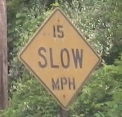
Continuing west, the first photo is very reminiscent of a state highway in the 1930s. The other two are not. But you can see from this angle how the road used to curve to the left to cross another wooden plank bridge, and how that design allowed the current bridges to be built in a straight line with the road.
Onto US 9
Back to NJ Roads
Back to Roads