New Jersey Roads - Bergen County
Bergen County

"But officer, it's only 9:30 in Daylight Savings! So what if it's December?" And as has been duly pointed out to me, the name "Constitution Park" is highly ironic for a place that limits as many freedoms as possible. This is on Fletcher Ave., which becomes US 9W to the north - click on that link at the bottom of the page to see the coolest sign on the street.

Pleasant Ave. in Rochelle Park, actually on the other side of the fence from Pleasant Ave. in Rochelle Park. It's on the other side of an abandoned railroad right-of-way to connect two streets that would otherwise be dead-ends.

Greg Pniewski submitted this shield, westbound at the east end of Zabriskie Street (he says - I didn't see it when I was there). This is registered as "C-21" in the NJDOT Straight Line Diagrams, and there's a "C-22" a block north and a block west, but the SLD's are known for numbering consecutive segments of county routes with '1', '2', etc. in the inventory system. This shield pretty clearly demonstrates that that was the case in Hackensack, and the DOT corrupted that into two numbers.

Liberty Rd. EB, CR 49, just past Tryon Ave. in Englewood. If that doesn't look like a 49 to you, it's because Bergen County has a dual route system. Low numbers (21 and under) were assigned to a gridlike system over existing county routes (25 and over). NJDOT doesn't recognize the new system, but sometimes all that's posted in the field is a low-numbered shield. Or none at all, which is usually the case. Don't follow route numbers in this county.

Perhaps the largest difference between posted and actual route, this is CR 130 SB as Page Ave. in Lyndhurst turns to become Schuyler Ave. Technically the arrow isn't needed with a driveway on the left but no road. Speaking of largest, click for closeup.

Heading north on Forest Ave. (CR 59 despite the 13 shields) through Paramus to the turnoff for 4th Ave. to Westwood.


CR 64 WB at CR 37.


Just off I-80 EB Exit 62B if you continue straight onto Railroad Ave. (first photo) and CR 81, Crescent Ave., entering New York (second photo).


CR 77 NB at the shortest multiplex in the county (7 runs along 77 here) and looking east along CR 90. The town is spelled Ho-Ho-Kus with the hyphens.

A rare spur county route courtesy Doug Kerr, photographed crossing over the state line from Rockland County. CR S-94, Spring Valley Road, magically changes into CR 92 at Ridge Rd.
 See?
See?
Heading north from Fremont Ave., CR 123., on Spring Valley.


Random Bergen County signage I nabbed.


Eastbound on Crescent Ave. from CR 87 and past a different Crescent Ave. (CR 81), of course after 101 has left the first Crescent.


Broadway (CR 104) NB at Woodcliff Ave. in Woodcliff Lake, and then at its end at Park Ave. in Park Ridge. Interesting how the main street names mirror the towns. Also interesting what it takes to keep a traffic signal up.


The normal state of Bergen County traffic signals and their supports, left and right from Pierrepont Ave. EB at Park Ave. (CR 30) in Rutherford.


The SB and EB beginnings of these two routes from CR 110 and CR 59, respcetively.


Westwood Ave., courtesy Charlie O'Reilly, and Demarest Ave. heading west from Cedar Lane as CR S-114 skirts the Hillsdale/River Vale border.

Last shield - Colonial Rd. SB bears right at Summit Ave.

But that's not it for old signs, here on Chestnut St. SB in Garfield approaching its end. Click for colorful closeup of the wear & tear.


Unique and noncompliant signs on Midland Ave. (CR 67) south at Passaic St. (CR 40) in Garfield, where Midland Ave. jogs right under a railroad track using Passaic St. The thru arrow is actually for a driveway and thru traffic should use the bent arrow, making this very complicated to figure out (I picked the right lane and had to politely merge left after I turned).


Vervalen St. WB in Closter. Old signs above and below.


Driving west on Ell Rd. in Hillsdale, I passed this dude's house.

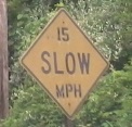
Of course, saving the best for last. This hand-painted yellow beauty has seemingly been here since Zabriskie Street got its crazy name, and maybe then some. It's at the eastern end of the dead-end road, the eastern block of which is Bergen CR C-2 (C- is for City, I guess, but the only other C- route is in the same city of Hackensack). It seems to only be there for private property, for cars and trucks turning to the back-side parking lot of an old warehouse. For the moment, it is sturdily bolted in, but that's only because I have insufficient tools. (And if you, daring miscreant, get to the sign before I do, please be kind and give me first dibs.) Click for magnificent closeup.
Broad Ave., Palisades Park-Englewood
Gregory Ave. Bridge, Wallington
CR 2
CR 36, Moonachie Ave.
CR 39 (and 17)
CR S-40 (Huyler Ave.) and State St. in Hackensack
CR 41 (and 17), River Rd.
CR 44, Central Ave.
CR 53
CR 55
CR 56 (and 12)
Fort Lee Rd., former CR 56
CR 57
CR 60
CR 61
CR 62
CR 63, Pascack Rd.
CR S-68, Ivy Lane
CR 69 (and 5)
CR 71
CR 78, Morlot Ave.
CR 79
CR 80/87 (and 6)
CR 84 (and 4)
CR 89 and S-89 (and 3)
CR S-91, Skyline Drive
CR 93 and S-93
CR S-104, Bogert's Mill Rd.
CR 112
CR 124
CR 134, Rock Rd.
CR 501 and NJ 63, NJ 93
CR 502
CR 503
CR 505
CR 507
NJ 4
NJ 5
NJ 17
NJ 67
NJ 120
US 1/9
US 9W
US 46
US 202 (Bergen CR 91)
Palisades Interstate Parkway
I-80
I-95
Bergen Co. route log
Charlie O'Reilly's Highways of Bergen County
Back to New Jersey Roads
Back to Roads

