Florida Roads - US 1 - Mainland - N. of Jupiter
US 1 on the mainland - North of Jupiter
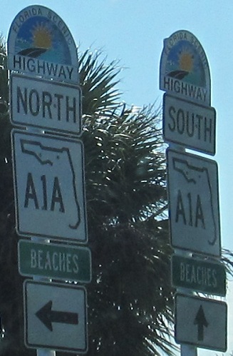
FL A1A is back to being a state route, SB at the north end of a short Fort Pierce concurrency.


SB at FL 713. Yes, in this order. Yes, US 1 intersects FL 713 twice, first with a one-way diagonal roadway that feeds directly in, then again where all the rest of the movements are made at a T intersection to the south.

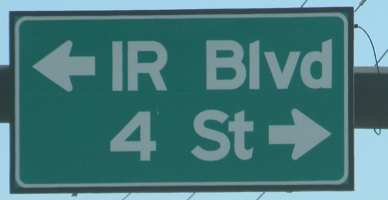

SB and overhead, from the cool (signals that blend with the pole) to the unfortunate ("IR" stands for "Indian River" in Vero Beach, but tourists probably will miss the turn every time) to the awful.

An old sign in front, a bad sign in back, SB. It needs borders and a legible layout.


Both sides of the SB road are intent on calling FL A1A "Beaches." "Beaches" works at the gentleman's club on 9 PM Monday through Thursday. Wednesday is dollar beer night.


Indian River County abandons specifications, decides they know how to round corners, fail miserably.


Signs, signs, what is wrong with signs? Pineda Causeway is treated just like another route, and CR 512 has some odd phrasing with "(WB)". Meanwhile, the other SB stuff is cool - Intracoastal Waterway (south of Palm Bay) and signals that blend in with the pole. I'm a fan of the ninja signals.
 I want to be the Mayor of Cocoa! Yum.

NB in Titusville where FL 50 heads to the left, courtesy J. P. Nasiatka. Left. LEFT! Can anyone hear me?


SB in Edgewater and beyond.


SB in the vicinity of old FL 44 in New Smyrna Beach, first photo courtesy J. P. Nasiatka. It's the same assembly, just that I found it after the signs were replaced. FL A1A goes Beachside many times, but this is one of the only times it doesn't come back - it dead-ends in Cape Canaveral (a.k.a. the Kennedy Space Center).

Buggy NB shields missing WEST (for FL 400) and arrows (for I-95 and I-4), courtesy J. P. Nasiatka. FL 400 is the eastern continuation of I-4 and may even be a secret or former designation for the Interstate.

All good SB, though it now occurs to me that the FL 400 sign should also be white on green, except for the shield, since it's a guide sign and not an assembly of smaller signs.


Whether SB or NB, this stark tower has no context. It's the radar tower for WESH, Channel 2, but this is hardly an advertisement to that fact. I'd watch their weather if I lived there, but only if I knew this cool tower was theirs.


Basilica of St. Paul, along US 1 SB in Daytona Beach. Signal timing and traffic will give you plenty of opportunity to photograph this landmark.

Northbound again, showing an older BGS with half-cutout shields, in Ormond Beach courtesy J. P. Nasiatka.


I'd rather have an old BGS without a state-name shield than the ugliness in the first photo. These photos are SB, sandwiching a fuzzy photo of County Route CR2002. See, "CR" means... Never mind. Order wider shields.


Non-cutout county shields, northbound in the St. Augustine area, courtesy Lou Corsaro.


SB to the same point with more non-cutouts and a Jersey-style US 1 shield, but a very un-Jersey "1/2" that should be twice the size.

Northbound, now in the Jacksonville area, courtesy Lou Corsaro. There's nothing special about the signage when it was taken, but a couple of years later, FL 9A was renumbered to a continuation of I-295 around the city, and at that point this became a historical photo.

Philips Highway momentarily looks nice, heading SB from the US 90 concurrency.


NB with US 17 on Main St., leaving downtown Jacksonville, similar to the signs down by FL 820 in the southern half of the state. Don't worry, it's not you, it's the sign.


State-name shields on the right (first two) and left, SB on the north side of Jacksonville right where US 1 becomes a freeway. This left turn is getting in the way of that, though. The interchange is one cloverleaf loop short of extending the freeway west... another 1,000 feet to FL 210. Okay, maybe it's not a big deal.

"US 23 sorta goes left, US 1 sorta goes right, but arrows cost money. We can just say they're both straight." Good luck heading southbound if you're relying on signs or a map.


Narrow shields SB (first photo) and NB (last two).

North of FL 104, north of I-295, north of Jacksonville, courtesy Michael Summa, and taken in 1989.
Continue south on US 1
US 90 and US 1/90
Onto US 301 and US 1/23/301
Onto Business US 1, St. Augustine
Alternate US 1, Jacksonville
Back to US 1 main page
Into Georgia on US 1
Onto FL A1A
To Florida's Turnpike
Onto FL 50
Onto FL 44
Onto FL 40
To I-4
Onto I-95
Onto I-295 (former/secret FL 9A)
Back to Florida Roads
Back to Roads