British Columbia Roads - BC 5
BC 5, Yellowhead Highway


The first few kilometres of BC 5 are also the first few km of BC 3. Then they split, yellow head to the left, crow's nest to the right. I don't know why they begin together, except that the Coquihalla Highway was constructed in 1986 to satisfy demands for a faster way to Kamloops, and that includes the Hope Bypass, but the road in Hope being bypassed was already part of BC 3. Maybe to keep people on the fastest route east, BC 5 inherits TCH 1's exit numbers instead of starting over. Incidentally, the first photo, at the merge from old BC 3, hints at two things: bicycles are allowed on the freeway, and BC doesn't care if they get run over by ramp traffic.

I hope this sign only displays the messages "OPEN" or "CLOSED," because it can't fit much else. If everyone's forced off the next exit, do you even need this sign? Also note that the BC 5 shield has a black square background, which is unusual for BC highway shields. Black on black. Finally, note that according to BC's own route log, technically the Yellowhead Highway only begins at Kamloops, and all of these should be regular shields. Shh, don't tell them. They decided to patch over all the BC 5 shields in 2011, so that may be the cause of the black background here.

I feel like the wrong way to make your words stand out is white on white. Maybe that was red once.


That sign preceded this NB trip through the Great Bear snow shed. I guess the mountain knows where to avalanche? I'm glad they added "in tunnel" to the Vision Limited sign, so that thousands of drivers a day don't suddenly think they're going blind and panic.


It's possible that's an original NB sign to the 1986 opening of BC 5. The SB services sign is just north of Kamloops past Shuswap Rd., and the wide font suggests a newer sign.
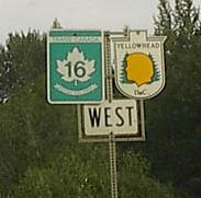
Courtesy Rich Piehl, both BC 5 and TCH 16 are the Yellowhead Highway, but since BC 16 is also the TCH, it gets the maple leaf in Tęte Jaune Cache, while BC 5 starts life with the yellow head. Now, Tęte Jaune Cache was named after Métis fur trader Pierre Bostonais, a blond or "yellow head" man, which is "Tęte Jaune" in French. He followed a route west from Winnipeg, 19th-century home of the Métis, to this point. That route is unsurprisingly now known as the Yellowhead Highway. As a fur trader, he needed to establish a settlement with buildings that would provide a safe place, or cache, to store furs away from prowling animals. Now that you know where the place name comes from, maybe it's clearer why both BC 5 and TCH 16 are known as the Yellowhead Highway. They are basically two branches from the place known as Yellowhead, and then the rest of it eastward is the route he took.
Exit 177 to BC 3
BC 5 Non-Roads
Back to British Columbia Roads
Back to Roads