BC 1A
BC 3, Crowsnest Hwy.
BC 5, Yellowhead Hwy.
BC 7
BC 15
BC 17
BC 17A
BC 77, Liard Hwy.
BC 91
BC 91A
BC 93
BC 97
Old BC 97, Kiskatinaw Rd.
BC 97C
BC 97D
BC 99
Dawson Creek
Kamloops
Ladysmith
Quesnel and Fraser River Footbridge
Vancouver Island
Vancouver area
Burrard Street Bridge
Knight Street
Marine Drive, West Vancouver
Pattullo Bridge
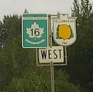
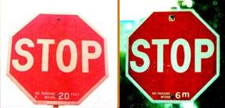
Here's the submittals section. First, courtesy Rich Piehl, the Yellowhead Highway follows TCH 16 throughout its journey from Winnipeg to Graham Island, BC. (BC 5 is its only spur.) Though you might not see the detail, B.C. is abbreviated beneath the head shield and spelled out in full beneath the maple leaf. Second, this dual photo by Averill Hecht shows the conversion from English to metric units in September 1977 - look on the bottom of the signs. Those say NO PARKING WITHIN (20 FEET, 6 m).