Alberta Highways - High Level Bridge, Edmonton
High Level Bridge, Edmonton


The uniqueness of this structure is easily visible from River Valley Rd. EB. It's built like a long rail bridge and the top level is indeed rail, but you see the second level beneath. Well, when this opened in 1913, it was a lot more than rail. The top level had the current single track but with a streetcar on each side. The lower level still accommodates vehicles and pedestrians, as it always has.


More views from underneath on River Valley Rd. The newer bridge to the west is an LRT bridge built in 1992, which you see also has provision for pedestrians underneath (and designed with bicyclists in mind). What's a jogger to do? If you're along the river, climb up the Dudley B. Menzies (that's the new one). If you're up the hill in downtown or Walterdale, you'll be on the High Level.


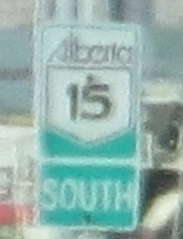
109 St. SB from 97 Ave. to the merge with 110 St. at the north end of the bridge. 109 St. and 110 St. both head southbound, making this the counterpart to the northbound Walterdale Bridge (see the big link at bottom). The green Alberta shield is an Edmonton special.


The photos only look repetitive because I'm a captive audience on the lower level. Hey, look, there's a sign. Which do I believe - one line (crossing legal but discouraged) or two lines (no crossing)?


All the fun signs are at the very end of the bridge. What's up with those spotted curve signs? They're on each side of the road to warn pedestrians and bicyclists of "hazardous girders" overhead. First of all, it would take someone over 9' tall to strike their head one one. Second of all, unless you're walking (or walking your bike), you don't have time to process what the black rectangles might mean and where they are. Third of all, the signs are just visible enough to traffic to confuse drivers. So do us all a favor, keep the gnarly old CAUTION CURVE, but ditch the Atari-inspired squiggle signs and just put reflective stripping on the girders in question.

Finally, off the south end of the bridge, it becomes apparent why there was so much open space overhead. This is the side track for the SB streetcar - yeah, it ran contraflow to the left of NB - that I mentioned used to run across the bridge. The SB side was chopped out to provide a little more clearance as the roadway curves upward from the lower level, but the NB side is intact. Now go back through the photos and imagine three tracks overhead instead of one. A little darker down there, innit? And more rumbly with the regular passage of trains overhead.
See more of Edmonton and its bridges
To AB 2
Back to Alberta Roads
Back to Roads